Friuli Dolomites
A wild and peculiar area
 |
| Italian |

Friuli Dolomites, more exactly The Friuli and Oltre Piave Dolomites are the UNESCO site further east among all nine. Cover a total area of 21.460 hectares in the provinces of Udine and Pordenone in Friuli Venezia Giulia and Belluno in the Veneto. This area is between the valleys of the Piave and the Tagliamento, Val Tramontina and the central part of Val Cellina, in which a winding canyon is located formed by the river Cellina.
 |
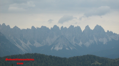 |
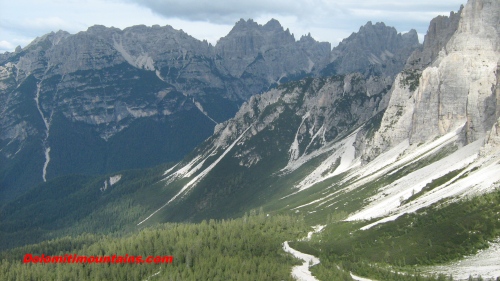
Many peaks characterized thr Friuli Dolomites
This is a very extended area and one of the wildest and most striking of all the Dolomites, protected and enhanced by the Friuli Dolomites Park, you can walk for days in these mountains and valleys without ever finding anyone. The major groups that extend from north to south, are Mount Cridola 2.581 meters high, Monfalconi with Cima Monfalcone of 2.548 meters of altitude, the Duranno-Cima Preti of 2.706 meters and the spectacular Spalti di Toro with Cadin di Toro of 2.386 meters and Cima Cadin degli Elmi 2.424. Latter range of mountains forms a large bowl with extended moraines at the feet, its shape is testimony to the fact that during the period of glaciation was a secondary glacier.
From the standpoint of Geology of Dolomites these part of Dolomites looks like a series of monotonous rocks of dolomitic limestone dated between Noricum and the Lias and therefore representative of the stratigraphic history of the Dolomites. Looking better, however, it turns out that in these mountains there are three superimposed main tectonic lines that produce an overlay that is repeated in sequence. These three layers consist of the Main Dolomite, more than half of the rock formations, which is followed by the Forni Dolomite, and more marginal, there are deposits of the Jurassic and more recent forms of the Cretaceous and the Paleocene-Eocene that found mainly in the valley of Cellina.
Near to these places, although not included among the UNESCO World Heritage Sites, is the valley of Vajont. This area south west of the site has become infamous in the autumn of 1963 because the Monte Toc landslide in artificial lake below, created by the Vajont dam. The wave that developed, over a hundred meter high, and falls on the opposite side on the countries of Erto and Casso and having channeled into the valley, fell on Longarone causing a total of 2000 deaths in a few minutes.
Discover the Dolomites
- History & Heritage
- Geology
- Nature & Environment
- UNESCO Heritage
- Regions and Destinations
- Major towns and villages
- Nature & Landscapes
- National Parks
- Climate & Weather
- Dolomites Maps
Things to Do
- Activities & Adventures
- Hiking & Trekking
- Rock Climbing
- Mountain Climbing
- Cycling & Mountain biking
- Skiing & Snowboarding
- Bobsleigh
- Snowshoeing
- Ice Climbing
- Family & Leisure
- Guided & Adventures Tours
Where to Stay
- Dolomiti Hotels
- Farmhouses
- Resorts
- Mountain Huts & Rifugio
- Bed & Breakfast
- Camping & Chalets
- Top Destinations
- Travel & Hotel Deals
Plan Your Trip
- How To Get There
- Travel Tips
- Best Time to Visit
- Travel Guides & Resources
- Deals & Discounts
Culture & Local Life
- Food & Gastronomy
- Restaurants
- Traditions & Events
- Historic Sites
Events & News
- Upcoming Events
- Local News & updates
- Special Offers & Deals
Contact & Community
- Contact Us
- Social Media & Blog
- FAQ & Help Center
- Dolomiti Links
Site Info